Fundy Trail Provincial Park
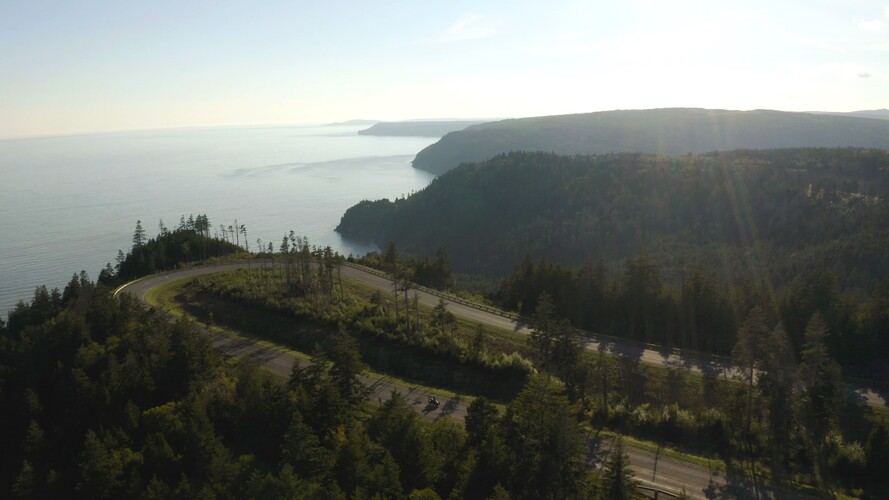


Covering the beauty of the southern coast of New Brunswick, this park is the perfect place to view the natural, unspoiled beauty of the Bay of Fundy and witness the highest tides on the planet! You can choose to experience our 30 km (19 miles) linear park by car, bike or hike our trails on foot. You can also kayak the bay and experience the coast from a whole different viewpoint. The possibilities are endless in this 6,323 acre coastal paradise.
Camping
Fundy Trail Provincial Park Campground
Please note the Fundy Trail Parkway campground is set to tentatively open July 1st, 2024. You will have to call the park at 1-866-386-3987 to book your spot. The campground will be reservable online for the 2025 camping season.
Phone
(866) 386-3987
Trails
Legend
 Easy
Easy
 Moderate
 Difficult
 Very Difficult
1 - Big Salmon River Loop
ClosedStarting Location: From the interpretive centre, facing the picnic tables on the hill, turn right and walk down the stairs. Follow along the chipsealed road until you come to a path near the river on your right. Follow this path along the Big Salmon River until you reach the stairs. Continue up the stairs and follow the trail until you return to the interpretive centre. This looped path may be walked in the reverse. The distance for this trail is measured for the full loop.

2 - Eye of the Needle
ClosedThe Eye of the Needle Trail in the Little Salmon Protected Natural Area, is a very technical and challenging trail. Since it is a linear trail, please remember that what you hike down, you must also hike up (making the trail a total of 2.4 km).
Descending and ascending on this in-and-out trail will involve holding onto chains on a narrow rock cliff edge, carefully navigating several steep switchbacks, and constant awareness of foot-placement and surrounding hazards.
This trail descends 180 metres down into the Walton Glen Gorge, characteristic of a narrow river canyon, with sheer cliffs on either side and the white water Walton Glen Brook running through it. The environment within the Walton Glen Gorge is extraordinary, but respecting the landscape is just as important to your safety as it is to conservation of this protected natural area.
Stay on the trail and use the trail at your own risk. Proper hiking footwear is a must. Sandals and sneakers are not recommended for this hike. Use caution on this trail as there are loose rocks and gravel.

3 - Walton Glen Gorge Shortcut
ClosedStarting Location: Park at P15. Proceed behind the reception centre building to your right and follow the marked footpath. This shortcut trail includes 65 steps and a short incline. The distance for this trail is measured for one way.
4 - Walton Glen Gorge Trail
ClosedStarting Location: Park at P15. Follow the wide trail from the parking lot about 100 m to the right of the building. You will pass the access to the McCumber Brook Wetlands on your right. Continue on this trail which will veer to your left. You will eventually come to a narrow pathway and a blue sign that will mark the end of the parkway land and the beginning of the Big Salmon River Protected Natural Area. Follow this pathway 100 m and you will arrive at Walton Glen Gorge. Some call this the ‘Grand Canyon of New Brunswick’, while other think it is much more spectacular. The distance for this trail is measured for one way.

5 - McLeod Brook Falls Loop
ClosedStarting Location: Park your vehicle in Parking Lot 15 (P15). This newly looped trail can start to the left of the Walton Glen Reception Centre or by taking the Walton Glen
Observation Deck Shortcut Trail.
If you choose to hike the Walton Glen Shortcut way starting out, you will depart this gravel trail and head into the woods about 600m in.
The distance for this trail is measured for the full loop.
3.8k includes the short detour to Walton Glen Gorge Observation Deck as well.
6 - McCumber Brook Wetlands Trail
ClosedStarting Location: Park at P15 near the entrance of the parking lot. Follow the wide trail from the parking lot about 100 m in front of the building. About 0.8 km from P15, turn right off of the wide trail onto the footpath to the wetlands observation decks. The distance for this trail is measured for one way.
1.2 km to Observation Deck A
7 - Link to Fundy Footpath
ClosedStarting Location: Park at P15 near the entrance of the parking lot. Follow the wide trail from the parking lot about 100 m in front of the building. About 0.8 km from P15, you will pass the footpath to the wetlands observation decks on your right. Proceed past the entrance to the wetlands trail to the next intersection. Do not veer to your left on the wide path. Stay straight and follow the footpath straight out to the Bay of Fundy. The distance for this trail is measured for one way.
8 - Footpath to Seely Beach
ClosedStarting Location: Park at P14 near the far end of the parking lot. Follow the footpath through the woods, crossing the parkway and follow the trail down the hill. Cross the brook and continue on towards the beach. The distance for this trail is measured for one way. Please note several trees are down across the trail and maintenance is in progress. Proceed with caution.
(Moderate to Strenuous on the return hike up the hill).
9 - Long Beach Brook Falls Loop
ClosedStarting Location: Park at P13. Walk out towards the parkway and travel west on the righthand side toward the interpretive centre. At the beginning of the guard rail you will see the footpath.
Follow the blue blazes through the trail to the falls. After reaching the falls and following the blue markers you will meander through a mossy forest. At the top of the hill at the old access road, turn right, down the hill towards the parking lot. Zig zag down the hillside and through back to P13. The distance for this trail is measured for the full loop.
10 - Big Salmon River Cemetery Footpath
Starting Location: Park at Cranberry Brook Lookout, space permitting. Otherwise park at P9. From Cranberry Brook Lookout, walk down the stairs to the picnic area, then continue to the path through the wooded area. There is a sign to mark the entrance to the trail. Be cautious as this narrow footpath is steep. The distance for this trail is measured for the full loop.
11 - Sea Captain's Burial Ground Footpath
ClosedStarting Location: Park in the lower part of P2. Cross the wooden bridge within the parking lot to connect to the trail. The distance for this trail is measured for one way.
12 - Low Tide Loop
ClosedThis 2 km loop takes you through the woods with clifftop views of the Bay of Fundy, before descending onto a tidal beach for your return. This trail has a moderate difficulty rating due to the cable ladder and uneven rocky surface on parts of the beach.
As implied by the name, this loop can only be accessed at Low Tide. Your hiking window is 2 hours on either side of Low Tide. Make sure to plan ahead and check the St. Martins tide charts.
Directions:
Set off from Long Beach P12 up the cable ladder and head East on the Fundy Footpath (Trail K), toward Seely Beach. This is along the Fundy Footpath trail, so the terrain is rugged. At kilometre 1 you will arrive at a cable ladder. Cable ladders can be quite steep and not always solid under foot- watch your step!
Follow the cable ladder down. At the bottom, take a couple steps to the left and cross the stream, follow the stream bed to the beach. Head West (to the right) back toward Long Beach.
Make sure to stop along the way and explore the neat elements of the ocean floor that are exposed at low tide!
The distance for this trail is measured for the full loop.
* Please note that this trail has a limited hiking window. As a general rule of thumb your window for completing this hike is 2 hours on either side of low tide. The beach section should be completed within that time frame.
Super tides or extreme high tides could shorten the window.
13 - Fundy Footpath
ClosedStarting Location: Park at P8. Facing the river, proceed to your left along the river. Walk under the Mitchell Franklin Bridge on the Suspension Bridge Trail. Cross the suspension bridge and you will see the sign for the trail head. Follow the footpath to your right. If your vehicle is remaining in the parkway overnight, please display a dated parking pass, available at all Kiosks, Big Salmon River Interpretive Center and Walton Glen Reception Center.
The Fundy Footpath (recently listed in the “50 Best Hikes in the World by Explore Magazine) is separate from the Fundy Trail Parkway although part of it does fall within our park. The footpath is a challenging wilderness trail that starts at the suspension bridge at Big Salmon River and hugs the coastline to the boundaries of Fundy National Park. Four to five days is recommended. The distance for this trail is measured for one way.

14 - Big Salmon to Long Beach Footpath
Closed(First Section of the Fundy Footpath)
Starting Location: Park at P8. Facing the river, proceed to your left along the river. Walk under the Mitchell Franklin Bridge on the Suspension Bridge Trail. Cross the suspension bridge and you will see the sign for the Trail Head. Follow the footpath to your right. The distance for this trail is measured for one way.
15 - Cranberry Brook Loop
Starting Location Park at P8. Facing the river, proceed to your left along the river. Walk under the Mitchell Franklin Bridge on the Suspension Bridge Trail. Cross the suspension bridge and continue straight up the hill. This trail is the old Salmon River Road. Walk up the hill, go past the entrance to Hearst Lodge Trail on your left and continue following the trail. This trail will loop around and cross the parkway. Continue to follow the trail and you will come to a 304-step cable ladder. Walk down the cable ladder and you will meet up with the Fundy Footpath. Continue to the right and follow the path back toward the suspension bridge. The distance for this trail is measured for the full loop.
16 - Hearst Lodge Scenic Footpath
ClosedStarting from parking lot P8, set off on the wide gravel path towards the Big Salmon River Suspension Footbridge. After crossing the footbridge, head to your left down a small hill. The trailhead to this narrow footpath sets off into the woods close to the river. The trail quickly becomes uneven underfoot with roots and rocks. There are punchy hills and wooden bridges along this trail. Please be cautious as this trail is currently under maintenance and can be slippery when wet. The distance for this trail is 1 way
17 - Suspension Bridge Trail
ClosedStarting Location: Park at P8. Facing the river, proceed to your left along the river. Follow the pathway and walk under the Mitchell Franklin Bridge on the Suspension Bridge Trail. The distance for this trail is measured for one way.
18 - Pioneer Loop trail
ClosedStarting Location: Walking from the interpretive centre, cross the road directly across from the building and continue up the hill on the path to the right of the picnic tables. This short trail makes a loop so you may either take the path to the right, proceed down the trail, up the small cable ladder and down the stairs or walk up the stairs, turn right and follow the path and proceed down the cable ladder back to your beginning point. The distance for this trail is measured for the full loop.
19 - Bradshaw Scenic Footpath
ClosedStarting Location: At Bradshaw lookout, follow the sign for the cable stairs at the foot of the hill of this lookout. The trail exits at Fuller Brook walking bridge. Continue left for Melvin Beach stairs and P3 or keep right for the Flowerpot Rock Scenic Footpath and P2. The distance for this trail is measured for one way.
20 - Flowerpot Rock Scenic Footpath
ClosedStarting Location: Park in P1 or at Fownes Head Lookout, space permitting. Walk down the stairs and follow the path. The distance for this trail is measured for one way.